


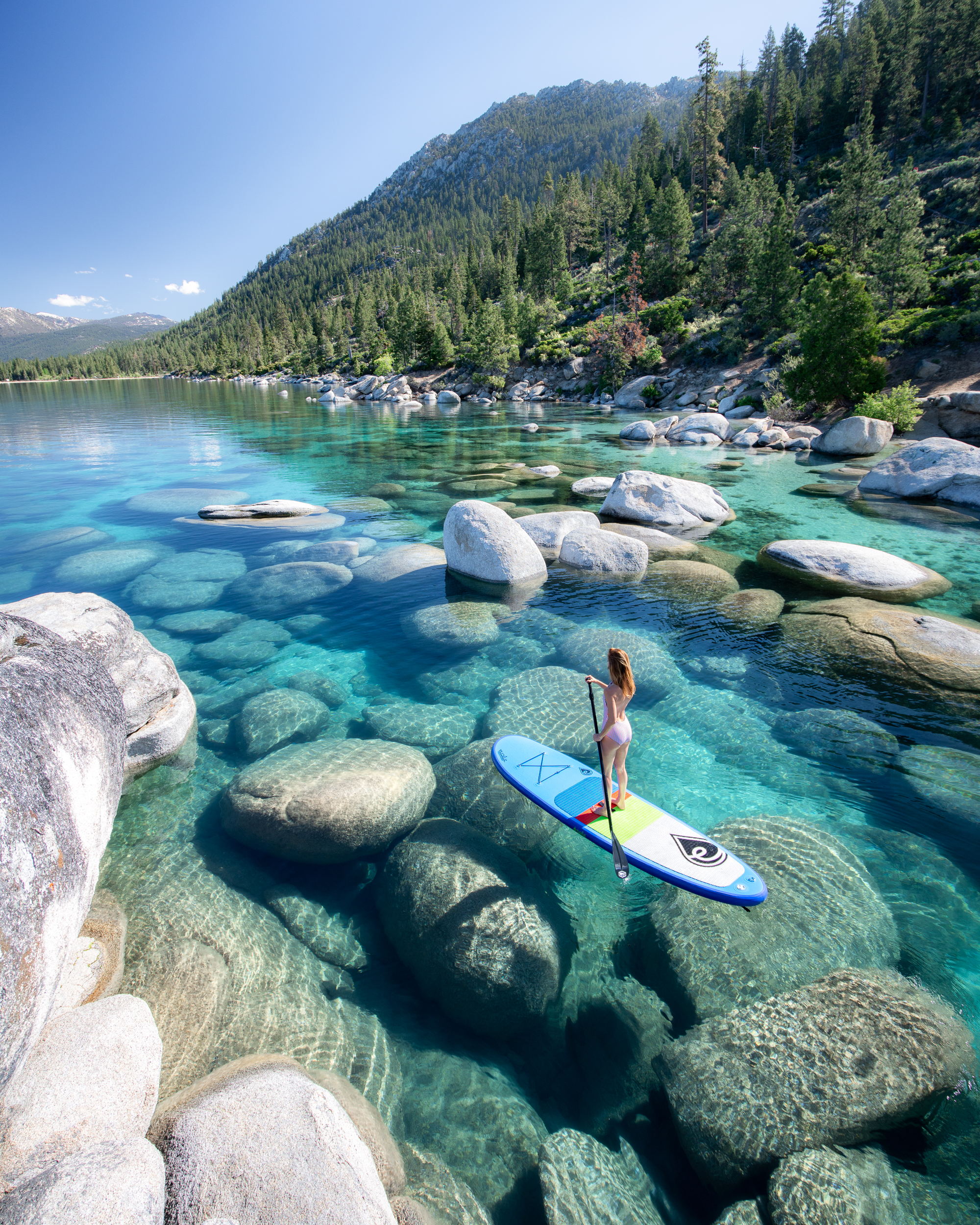
Mineral King Loop: Life Imitating Art
If you’re a fan of landscape photography, then you are undoubtedly familiar with Ansel Adams. And if you’re familiar with Adams’ work, chances are at some point you’ve come across his iconic image of Precipice Lake.
It was 1932, and Adams was hiking through Sequoia National Park when he found himself face to face with the hypnotic body of water now known as Precipice Lake. Nestled in the heart of the Mineral King wilderness, Adams remarked that he “was impressed with the solemn beauty of the scene and saw the image quite clearly in [his] mind.”
I grew up hiking and backpacking, but it wasn’t until I visited an Ansel Adams photography exhibit during a family vacation in middle school that the two activities—hiking and photography—became forever intertwined. I’m always struck by how sometimes the most innocuous events leave the most significant impression.
Adams inspired my love of photography, my first post on Instagram, and now this backpacking trip around the Mineral King Loop to experience the same solemn beauty that he captured so profoundly almost a century ago.
Hiking The Mineral King Loop Trail: At A Glance
The elevation at the floor of the Mineral King Valley is 7,500, and pretty much anything you want to see in the area requires a significant amount of elevation gain from there. To complete this particular loop, you’ll hike through multiple passes, traverse part of the High Sierra Trail, and down into an enchanting Redwood grove.
Needless to say, the elevation gain and loss throughout the route makes this a strenuous trip. The relatively high elevation and the overall distance don’t help. Quin and I tackled this as our first backpacking trip of the season – and we definitely felt it. Luckily, nature is the best medicine, and the scenery on this trip kept us pretty doped up!
Distance: Approximately 47 miles
Elevation Gain/Loss: Approximately 11,500 ft
Trailhead: Sawtooth Pass (located about a quarter-mile from the Mineral King Ranger Station)
Direction Traveled: Clockwise
Difficulty: Strenuous
Pets: Pets are not allowed on any trails in Sequoia National Forest and Kings Canyon National Parks
NOTE: For this trip, we used the Tom Harrison Mineral King Map, AllTrails, and trail signs to navigate. Unfortunately, these three resources provided different (sometimes significant) mileage reports. With that in mind, I have done my best to give what I believe to be relatively accurate distances for each leg of the trip.
What To Pack: Backpacking Gear For The Mineral King Loop
Whether you are heading out for a quick day hike or something a little more ambitious, the right gear can make the whole experience smoother and way more enjoyable. This is the setup I’ve been using lately out on the trail, including the pieces I reach for again and again because they actually work in real conditions.
DON’T FORGET! You should always carry The TEN ESSENTIALS for outdoor adventure with you. They might just save your life!
Packing & Organization
BACKPACK – The Osprey Eja (women’s) and Exos (men’s) are great packs for hikers who want to lighten their load but aren’t ready to give up comfort and support. They’re heavier than cottage ultralight packs, but that extra weight gives you a sturdy frame, excellent ventilation, and a suspension system that keeps heavy loads feeling comfortable over long days. And it’s still much lighter than a more traditional pack with all the bells and whistles.
Shelter and Sleep Gear
SLEEPING BAG – The Feathered Friends Egret UL 20 has been my go-to sleeping bag for the last two seasons because it’s lightweight, insanely warm for its weight, and compresses small enough to save space in my pack.
SLEEPING PAD – As a side sleeper, I’m picky about sleeping pads, and the NEMO Tensor Trail Ultralight Insulated Sleeping Pad is one of the only ultralight pads I’ve found that’s genuinely comfortable (for a sleeping pad). After years of use, it’s proven reliable and worth every ounce.
BACKPACKING PILLOW – The Sea to Summit Aeros Premium Pillow is the best ultralight pillow I’ve found. Does it feel like your pillow on your bed at home? NO. But, it’s still one of those little luxuries I never regret packing.
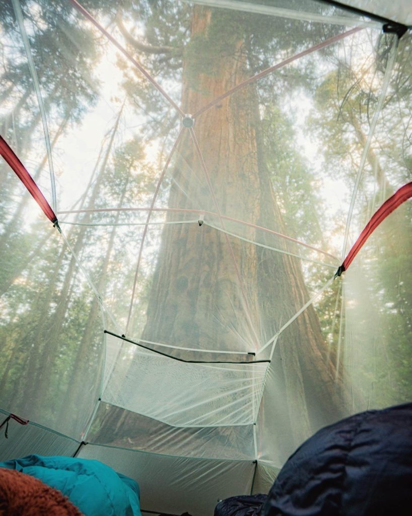
TENT (TWO PERSON) – The Big Agnes Copper Spur UL2 has been my go-to backpacking tent for years because it’s roomy, ultralight, and incredibly reliable. It’s also a true freestanding tent, which means it can stand on its own without stakes — a huge advantage when camping on rocky terrain or spots where staking isn’t easy.
Food, Water, & Kitchen Gear
ULTRALIGHT STOVE – I recently swapped my Jetboil Flash for the Soto WindMaster with 4Flex pot supports because it’s lighter and more versatile. You can use different pots, not just the Jetboil mug.
COOK POT – The TOAKS Titanium 750 ml Pot, perfectly fits a 110g Fuel Canister (the smaller standard size that you see), WindMaster Stove, and a mini BIC Lighter.
EATING UTENSIL – The Snow Peak Titanium Spork (Long)
WATER PURIFIER – The Katadyn BeFree is my favorite filter for speed and simplicity. It’s ultralight, easy to squeeze, and perfect for quickly filling bottles on the go.
The Grayl Water Filter is much heavier but unbeatable for international travel or areas with questionable water sources because it removes viruses as well as bacteria and protozoa. It works like a French press—fill, press, and drink—with no need for extra bottles or gear.
FOOD STORAGE (BEAR SAFE) – The BearVault BV450 Jaunt Bear Canister. This size is generally considered good for 4 nights, or 2 night trips with 2 people.
The Ursack is a lightweight alternative to a bear canister. It’s made from bulletproof-grade fabric that resists chewing and clawing, and it’s much easier to pack in your bag. You’ll still need to tie it to a sturdy tree, and it doesn’t protect your food from getting crushed, but for trips where bear canisters aren’t required but you still want to protect your food from bears and other critters.
Other Backpacking Gear
HEADLAMP – Nitecore NU25 400 Lumen Rechargeable Headlamp
GPS COMMUNICATION – I carry the Garmin InReach Messenger Plus for peace of mind on backcountry trips — it lets me send texts and share my location even when there’s no service. The battery lasts for days, and it’s a small, reliable way to stay connected and safe when I’m off the grid. AND you can send photos and voice notes! Watch the video I made about the Garmin Messenger Plus!
SMART WATCH – I’ve been wearing the Garmin Fenix Watch to track my activity for years. Plus it’s so fun reviewing and sharing hike details after!
TREKKING POLES – Durston Iceline Trekking Poles. I just picked up the Durston Iceline trekking poles because I wanted something ultralight but sturdy to take pressure off my knees on big hikes. They’re incredibly light (under 10 oz per pair) and designed for strength.
MULTI-TOOL – Swiss Army Classic Knife
FIRST AID – Band-Aids, Leukotape, pain killers, anti-bacterial cream.
REPAIR KIT – Repair Spool by Igneous, Tenacious Tape.
POWER BANK – Nitecore Power Bank
Clothing Essentials
SUN SHIRT – The Crater Lake Hoody is my favorite sun shirt because it’s so light and soft it almost feels like air. It offers full UPF 50+ protection for long days in exposed terrain, so I don’t have to carry buckets of sunscreen.
SHORTS – You don’t need to reinvent the wheel here. Whatever works for you! This summer I’ve been really enjoying the Lululemon Pace Rival High Rise Shorts and Outdoor Voices Warmup 5” Shorts.
HIKING PANTS – To be honest I’ve never been a big hiking pants person. I generally just wear one of my favorite pairs of leggings, because that’s what I’m most comfortable in. But this summer I picked up a pair of REI Trailmade Pants and they were nice! The Trailmade Pants are affordable, durable, and surprisingly versatile for hiking and backpacking. And I have to admit it was nice to have pants that felt a bit more airy than leggings.
INSULATED LAYER (Down Jacket ) – The Patagonia Fitz Roy Down Jacket is a cold-weather essential I bring on alpine or winter trips when serious warmth is non-negotiable. It’s stuffed with premium 800-fill down, so it’s incredibly warm for its weight. I’d recommend sizing down.
When I’m really trying to go lighter without sacrificing warmth it’s hard to beat Rab’s Mythic G Down Jacket. Best to pick this one up on sale if you can!
RAIN JACKET: The Rab Phantom Jacket is an ultralight, fully waterproof shell that packs down small and disappears in your bag until you need it. I’m a fair weather hiker, but in the mountains weather can change fast, so it’s great to have rain protection that doesn’t weigh me down.
For more inclement whether, when I want something a little more substantial, I use the Arc’Teryx Beta SL Jacket.
Shoes
TRAIL RUNNERS – The Hoka Challenger Trail Running Shoes are my go-to shoe for warm weather hiking. I prefer trail runners over hiking boots because they’re lighter, more breathable, and dry quickly. I’ve worn mine on everything from day hikes to multi-day trips like the John Muir Trail, and they’ve been incredibly durable for how lightweight they are.
BOOTS – The Danner Inquire Chukka Mid is my all-time favorite hiking boot! I wear it when I want more ankle support than a trail runner but still need something light and flexible.
Camera
SONY RX100 VII – The Sony RX100 VII is my favorite compact camera for backpacking because it’s small enough to slip in a pocket but still delivers professional-quality photos. The 24–200mm zoom range makes it incredibly versatile, and it’s the perfect option when I don’t want to carry one of my heavier cameras but still care about image quality.
| Just a quick heads up. Some of the links in this post are affiliate links, which means I might earn a tiny commission if you decide to make a purchase. It does not cost you anything, but it’s one of the simplest and most supportive ways to help me keep creating these guides. I’m not paid to recommend anything, and every opinion here comes from real experience with gear I actually use and love. If you’re planning on picking something up, using my link truly makes a difference and I appreciate it more than you know. |
Backpacking The Mineral King Loop
Photographing Precipice Lake was the sole objective of this trip when Quin first floated the idea. And the simplest way to achieve that objective would have been to do a simple out and back hike on the High Sierra Trail. But as I started researching routes, I found myself deep in a Sierra backpacking rabbit hole. And as I continued to dig, one area, in particular, kept popping up.
That area was called Mineral King. It was remote, offered everything from alpine lakes to redwood groves, and most importantly, there was a route through the area encompassing Precipice Lake. Better yet, the trails could be connected to create a loop. It seemed like a no-brainer to me.
So I applied for the Mineral King backpacking permits, packed my bags, and the next thing I knew, we were parked outside the Mineral King Ranger Station, ready to hit the trail.
Day One On The Mineral King Loop: Sawtooth Pass Trailhead to Redwood Meadow Grove / 10 miles
We arrived at the Mineral King Ranger station as soon as it opened at 8:00am. When I’d booked the Mineral King backpacking permits, I didn’t recognize the names of any of the camp locations, so I panicked and requested the wrong campsite for our first night. Luckily the ranger was able to sort us out. He went over our planned itinerary, gave us a bear box for the trip, and lent us a tarp to “marmot proof” the van.
It took about an hour to get the van ready at the trailhead parking area. We had to store all our food in the provided bear lockers and wrap the giant tarps around the van’s undercarriage to protect it from the local marmot population. Apparently, they’ve developed an appetite for radiator hoses and car wiring in this area. Once we were done securing what amounted to a giant car diaper, it was time to hit the trail!
NOTE: The Mineral King marmots don’t only enjoy munching on car parts. They also love the salt found in human sweat, so keep your backpacks, shoes, and any other items you’ve sweated on close.
There’s no easing into the Mineral King Trail. It throws you right into the deep end. The trail starts with a long series of steep switchbacks that eventually take you up over Timber Gap. Even after toiling for half an hour under the brutal midday sun, we could still see the van and its bright blue diaper parked down below, almost mocking us with its proximity.
It was demoralizing, to say the least. I would highly recommend getting an early start to avoid hiking this exposed section in midday heat.
Eventually, the trail took a turn, and we found ourselves meandering through a gloriously shady forest. At Timber Gap, we stopped to regroup and take a moment to embrace the fact that the rest of our day was all downhill. In fact, over the next 6 miles or so, we would not only lose all of the elevation that we had just gained, but would actually descend around 3,000 feet to end up at a lower elevation than where we had begun the day.
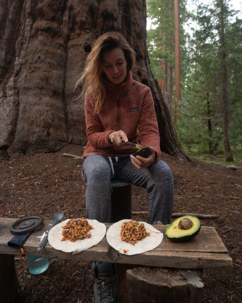
At Cliff Creek, we had our first river crossing, and even though we could have easily done it without taking our boots off, the day was too hot and the water too glorious to not get in. Cliff Creek is a great spot to take a load off, cool down, and filter some water before completing the next 4 miles to Redwood Meadow Grove.
NOTE: Taking the opportunity to fill up your water at Cliff Creek is especially prudent if you plan on camping in Redwood Meadow Grove as we did. There’s no water in the grove, and while there may be a few other opportunities between Cliff Creek and your camp, Cliff Creek is by far the most obvious and plentiful water source along this portion of the trail – especially later in the season.
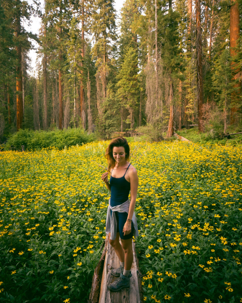
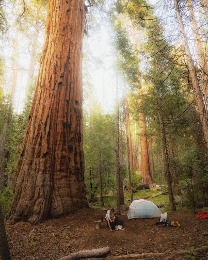
Arriving at Redwood Meadow Grove, we were greeted by a scene straight out of a Brothers Grimm Fairy Tale. Low afternoon light flickered through the canopy casting a golden glow over the forest floor. The glow was only accentuated by the sea of yellow wildflowers that flooded any space left between stands of ancient redwoods. In the midst of it all, a quaint log cabin sat quietly in a small grove.
Built in 1938, the rustic Redwood Meadow Ranger Station was unoccupied, but I wouldn’t have been half surprised if an old woman with suspiciously big eyes and sharp teeth had stepped out and offered me some candy.
The designated campsites for Redwood Meadow Grove are located on the left-hand side of the trail about a quarter-mile past the Ranger Station. We missed them on our first go, but I think we were just distracted by the beauty of it all.
Day Two On The Mineral King Loop: Redwood Meadow Grove to Precipice Lake / 13 miles
I had nightmares about giant redwood branches crushing the tent in the middle of the night. Maybe that’s the flip side of an enchanted forest – too many things that go bump in the night. The point being, I woke up ready to climb up out of the forest and into the alpine.
And it’s a good thing, because day two was one of the more grueling days I’ve ever had backpacking. Luckily, it was also one of the most beautiful days I’ve ever had backpacking.
The trail eased us into our second day. The first two miles were relatively flat until we began the climb up to Bearpaw Meadow. There’s an active ranger station at Bearpaw Meadow in the form of yet another cute log cabin. There are also some established campsites just before you reach the ranger station.
Many backpackers that complete the Mineral King Loop trail choose to spend a night here. Not us. We had places to go and things to see. So after a quick water break (there is a faucet outside the ranger station), we kept moving.
NOTE: Most years, there is a full-service High Sierra Camp located at Bearpaw. Guests at the camp stay in rustic tents overlooking dramatic views of the Western Divide while the on-site staff provides fresh-cooked breakfasts and dinners. You’ll also be treated to hot showers and flush toilets. To reach Bearpaw High Sierra Camp, you hike 12 miles one-way along the High Sierra Trail starting from the Crescent Meadow Trailhead.
From there, you can enjoy a number of day hikes from camp – including Precipice Lake. Unfortunately, the camp closed for the 2021 season due to issues with its water infrastructure and it still remains closed at the last check (2025 season). But you better believe it’s on my bucket list!
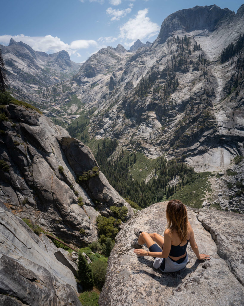
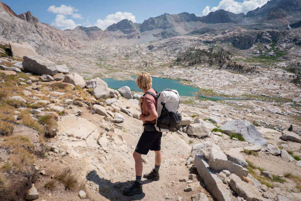
At Bearpaw Meadow, we joined the High Sierra Trail, and it didn’t take long to understand why this historic trail is so iconic among hiking enthusiasts. Within a mile, I was experiencing sensory overload.
Expansive views stretched out in every direction. Towering peaks, vertigo-inducing valleys, and enough granite to give Yosemite a run for its money stretched out in every direction. Needless to say, the cameras came out, and despite the gentle downward grade of the trail, our forward progress took a dramatic turn for the worse.
About 2 miles past Bearpaw Meadow, we crossed a large bridge, and it was here that the uphill climb really began in earnest. . . and didn’t stop for the next 9 miles or so.
But don’t fear; there are countless beautiful views, tranquil watering holes, and shimmering alpine lakes to keep your spirits high.
The next major benchmark on our Mineral King Loop was Hamilton Lakes. We had only seen one other group of backpackers on the trail over the past two days until this point. So it was a bit of a shock to the system to arrive at Hamilton Lake and see people again.
People in tents, people in hammocks, people sunbathing and swimming. I wouldn’t go so far as to say it was crowded. . . but there was no doubt that Hamilton Lakes wasn’t just a benchmark for most people. It was the destination.
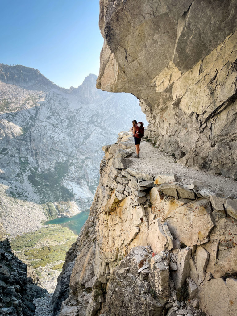
I found myself wondering where they had all come from, but I didn’t have time to ask because we had another 4 miles and 2,000 feet in elevation to gain before we made it to our destination – Precipice Lake.
I’m not going to lie; the stretch between Hamilton Lakes and Precipice Lake was both physically and mentally taxing. It was late afternoon, I was exhausted, and quite frankly jealous of the people—now merely tiny specks—napping down in their hammocks at Hamilton. But Precipice was within our grasp now, and we pushed forward.
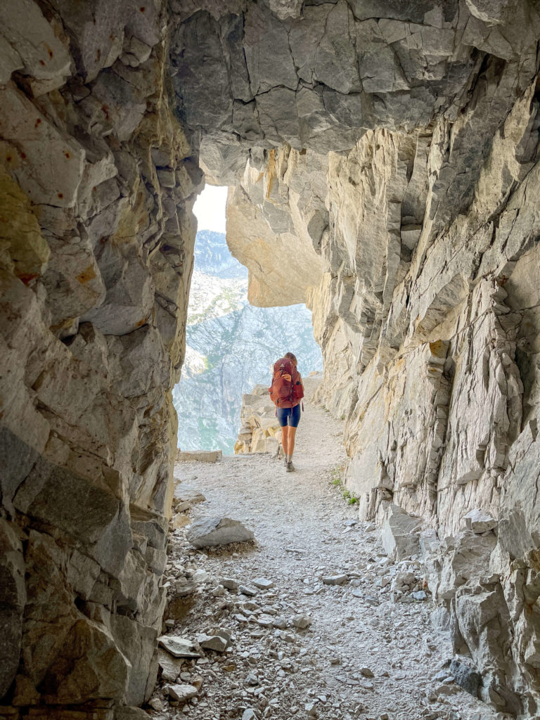
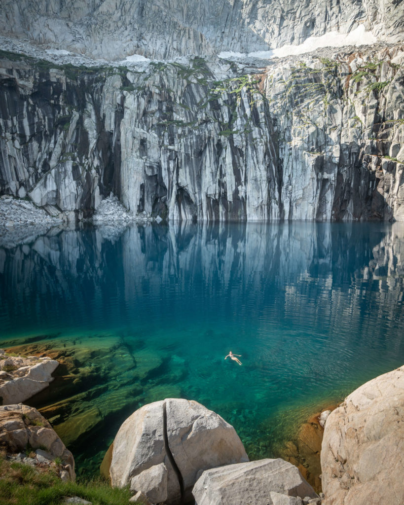
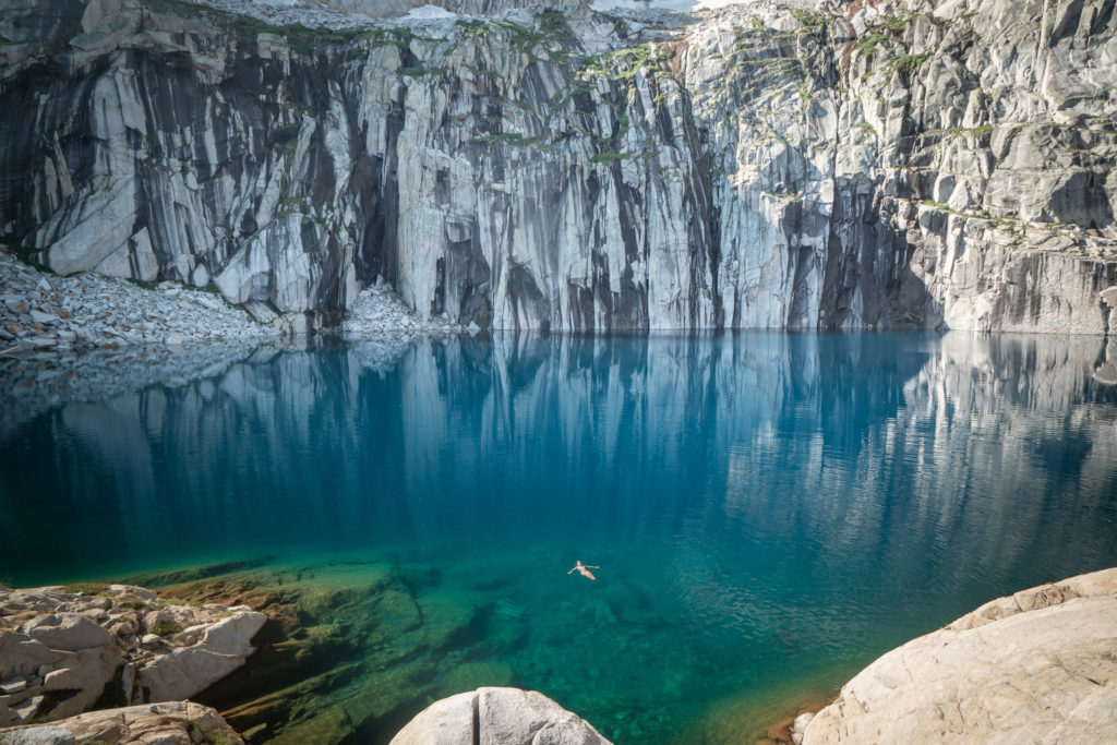
To be fair, this section of the High Sierra Trail is genuinely spectacular. An engineering feat, really. I found myself asking, “how did they do it” over and over again. And even “Why” a few times. Before I could work any of this out, I looked up from my feet, and in what I can only describe as a semi-delirious state, witnessed the mountain in front of me melt into the ground.
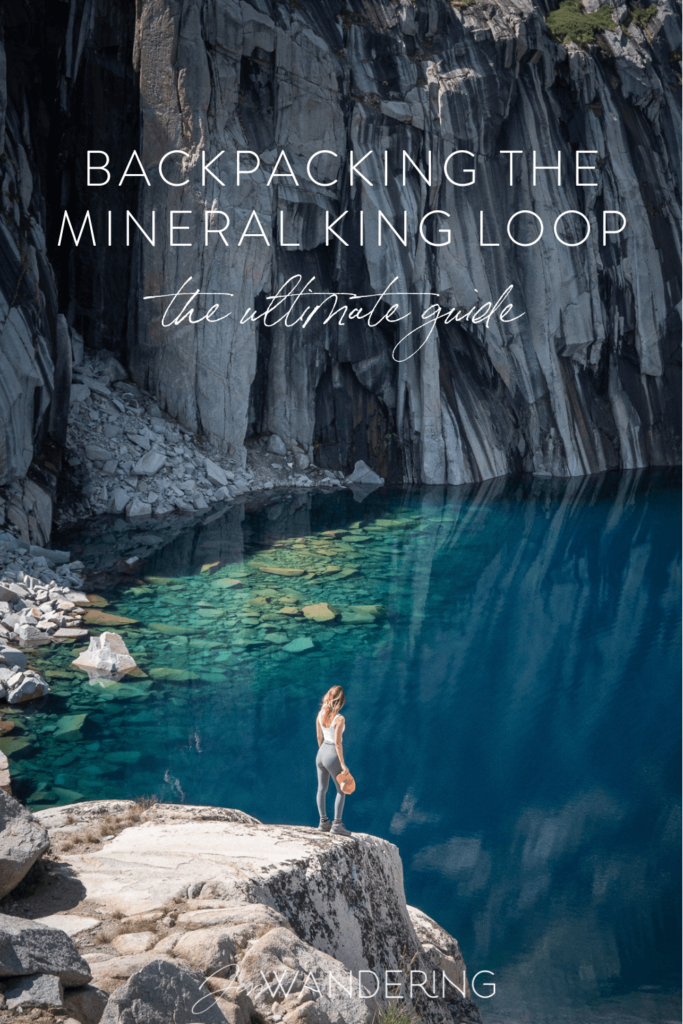
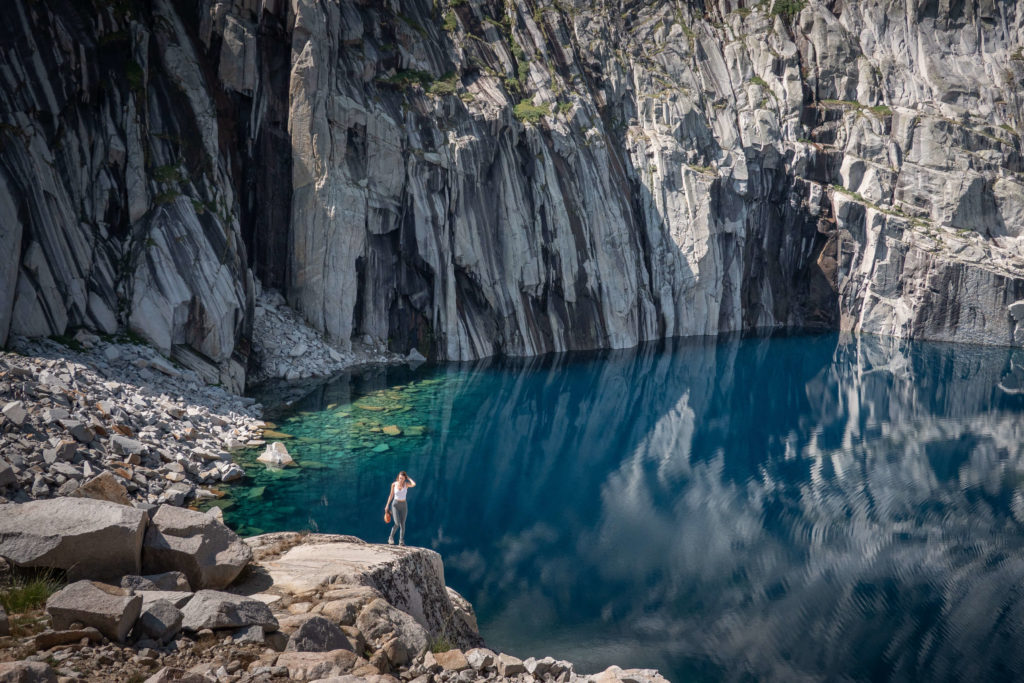
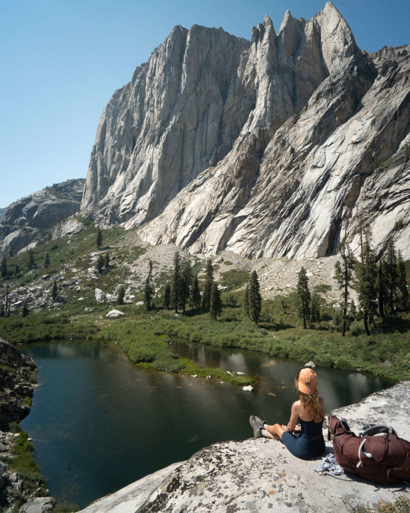
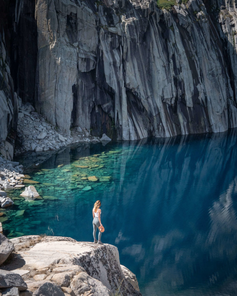
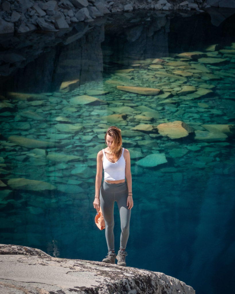
Or at least that was my addled brain’s first impression. Then I realized it wasn’t the ground at all. It was a lake. It was Precipice Lake.
The lake was so calm that the mountain’s reflection jumped off the water with the intensity of a solid. It defied logic.
It was everything I dreamed it would be – and more. Quin’s voice broke through my momentary hypnosis, “we need to shoot!” He was right. It had taken hours longer than we had expected to get up here, and the daylight was quickly melting away.
I dropped my backpack and summoned the last remaining drops of energy at my disposal. We ran around trying to capture the moment before it was gone forever. I’m not sure it’s ever really possible to do a destination like Precipice Lake justice in photos, but we sure had fun trying.
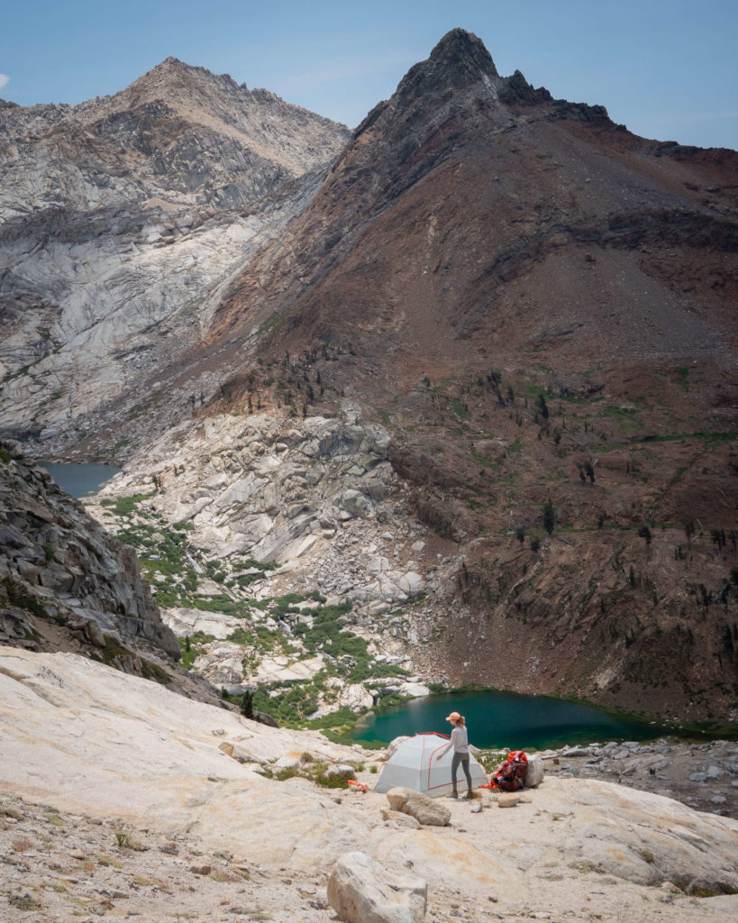
Day Three On The Mineral King Loop: Precipice Lake to Lost Canyon Creek / 13 miles
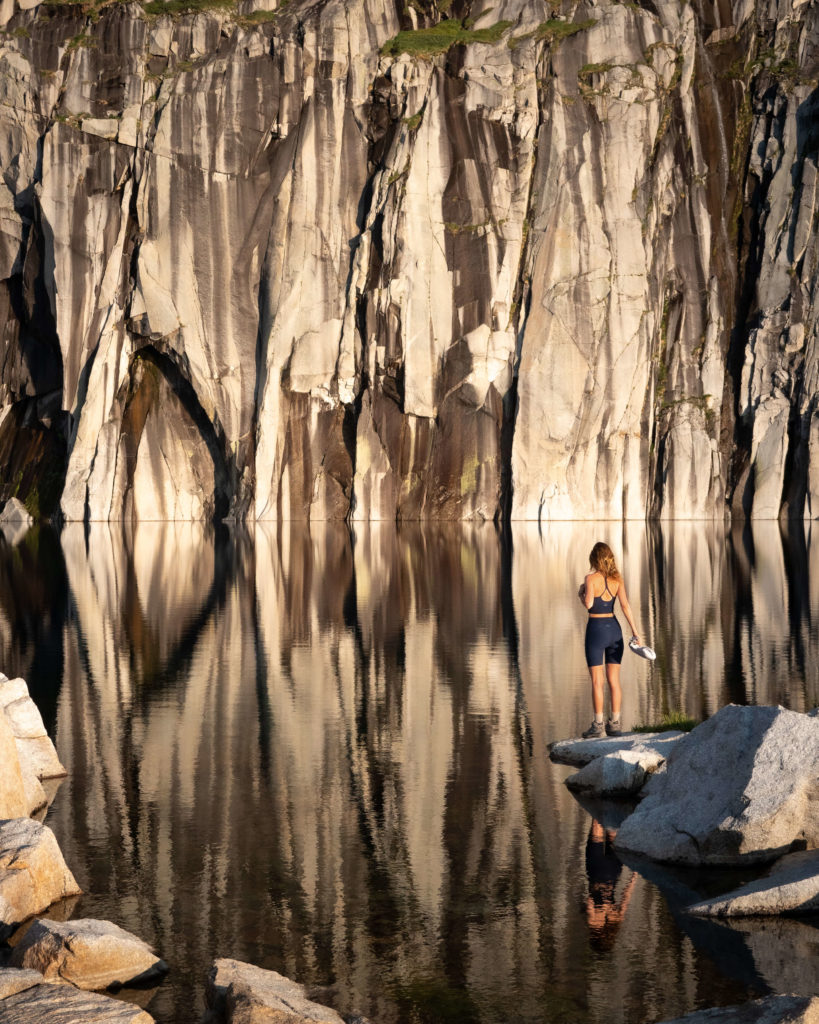
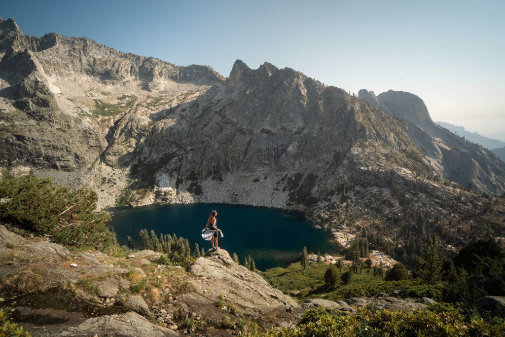
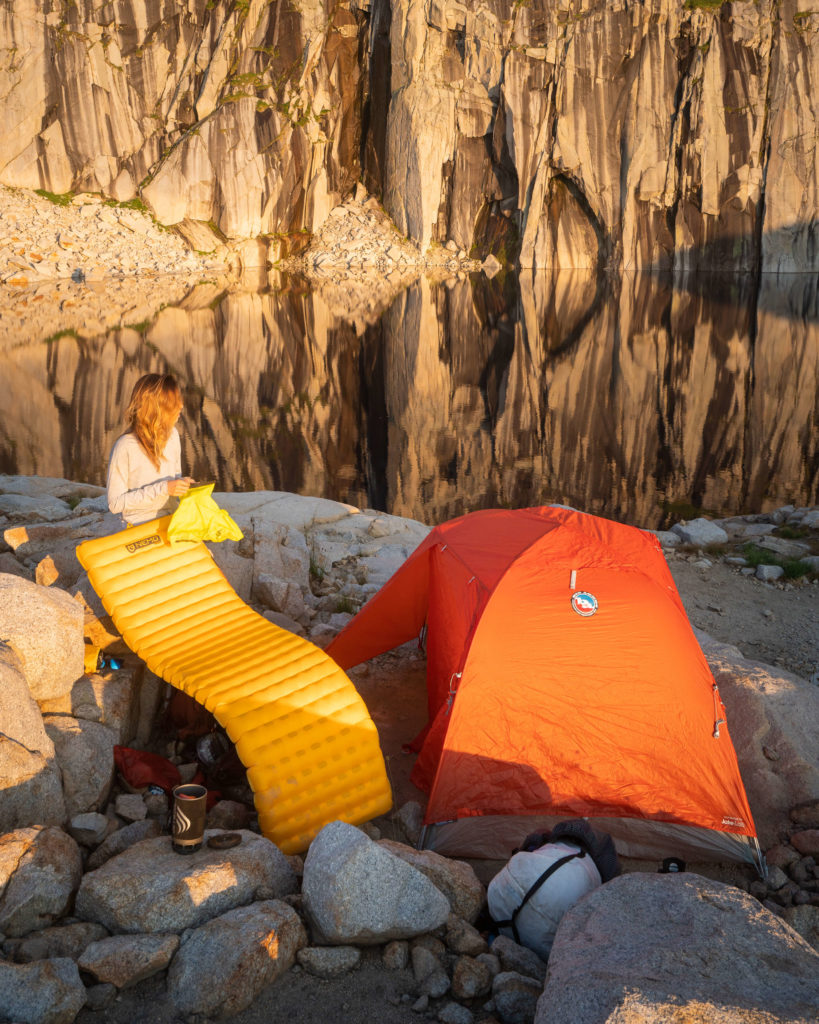
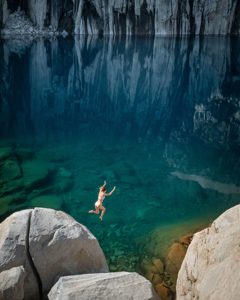
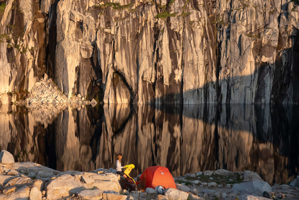
I woke up to the sound of our neighboring camp packing up, and by the time we rolled out of the tent, we had Precipice Lake all to ourselves. It’s hard to say whether the lake was more striking in the evening with the sinking sun casting a golden hue across the rocks or in the morning as the rising sun illuminating the bright blue color of the water. Luckily, we didn’t have to choose. And that is perhaps my favorite thing about backpacking.
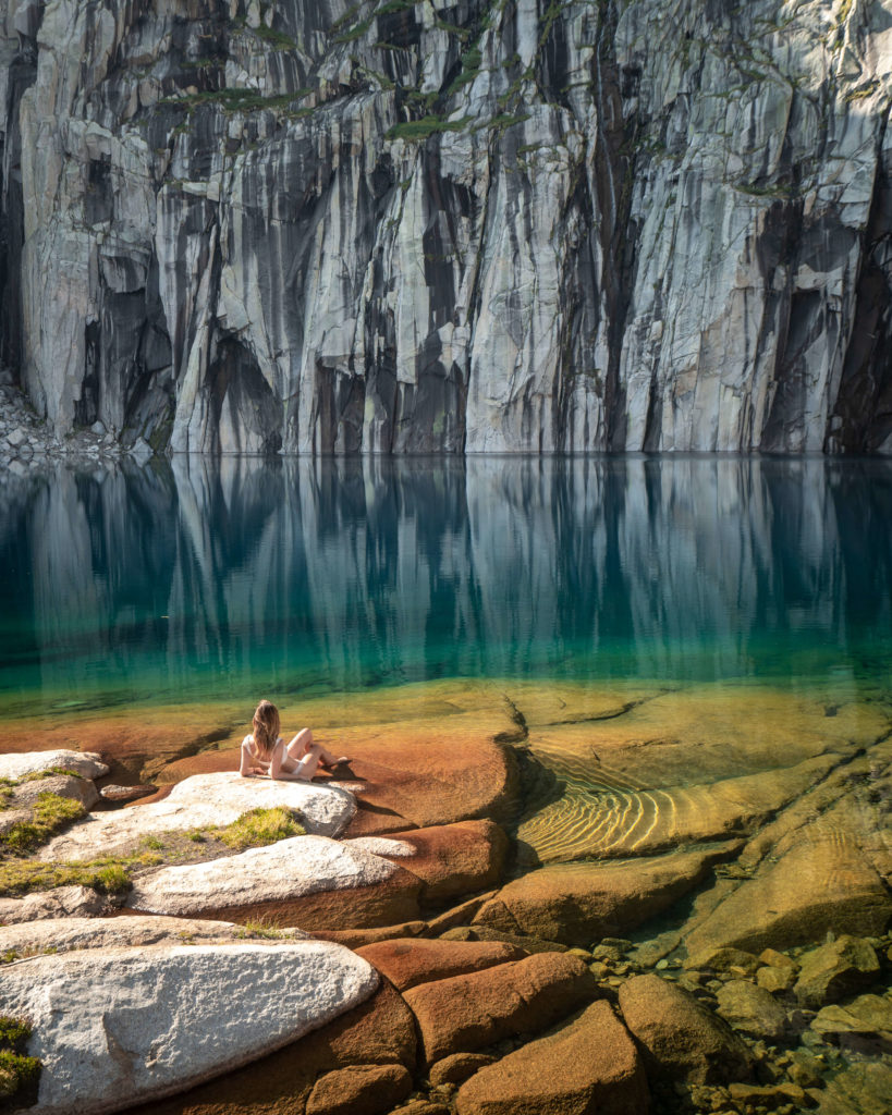
Our bodies were sore from the effort of the previous days, and we took the opportunity to spend the morning swimming and then relaxing in the sun on warm granite slabs. It was the perfect remedy for weary muscles, and neither of us wanted to leave.
So much so, that we seriously debated spending another night at Precipice. We had packed an extra day’s worth of food as part of our “Ten Essentials,” but also in case we came across something on our journey that demanded more time. Something exactly like this.
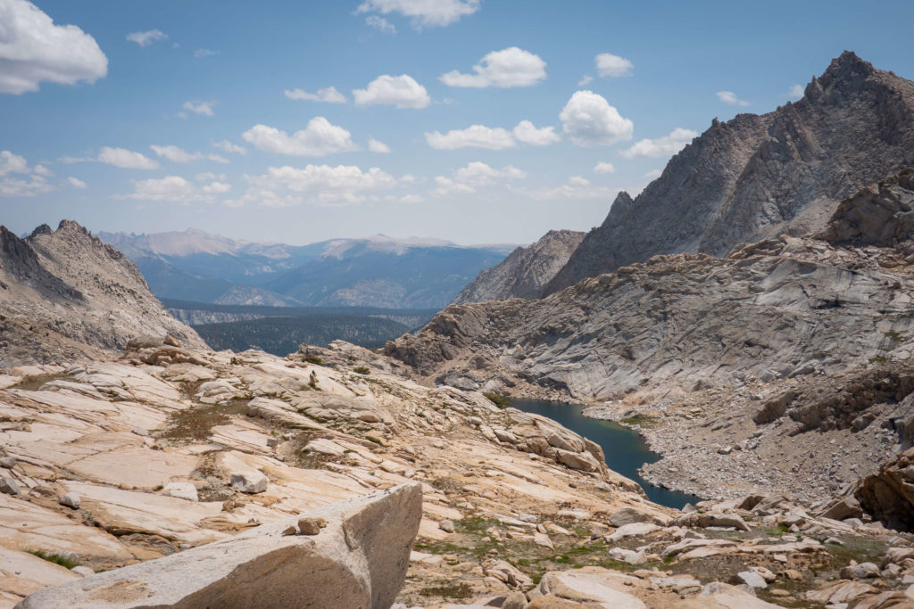
In the end, we decided that we still had a long way to go (we were only about halfway through our loop), and the prudent thing to do was save the food and keep covering ground. So it was with full yet heavy hearts that we packed up camp, took one last dip in the lake, and started the short but steep trek up the final stretch of Kaweah Gap.
From Kaweah Gap, the remainder of our time on the High Sierra Trail was a blessedly mellow downward grade. We cruised along, taking in the views and basking in the afterglow of that morning at the lake.
There was a lot to be happy about. Not only had Precipice Lake lived up to our wildest expectations, but our third day on the trail was also meant to be our shortest. Soon we would turn off the High Sierra Trail and head for Little Five Lakes, a mere 3 miles further, to set up camp. At least that had been the plan…
But as we cooled down our feet in the first of the Little Five Lakes, it became apparent that we were in for a massive last day if we stopped here. We still had an extra day of food, and we had initially thought that if the fourth day proved to be too much, we could break it up by spending the night at Columbine Lake.
I had read that Columbine was beautiful and a favorite campsite for backpackers in the area. But after talking to the park ranger stationed at Big Five Lakes, it was clear that wouldn’t be an option. Camping at Columbine Lake was no longer permitted due to the lack of places to responsibly relieve yourself. So it was back to the drawing board.
It was still early afternoon, and we were both feeling pretty good, so eventually, we decided to just keep hiking. We didn’t really have an exact location in mind. We would walk until we dropped or until it got dark. In the end, we called it a day at Lost Canyon – a beautiful area with ample campsites and water galore.
And while Big Five Lakes was lovely, in hindsight, neither of us regretted that it was now in a rearview mirror. And we certainly didn’t regret it the next day.
Day Four On The Mineral King Loop: Lost Canyon Creek to Sawtooth Pass Trailhead / 11 miles
This was it. The last day of our Mineral King Loop backpacking trip. Is there anything more exciting than getting back to the trailhead after a strenuous hike? If there is, I certainly couldn’t think of it that morning!
I’m getting ahead of myself though. It was too soon to start talking about hot showers and burritos. Our last day wasn’t going to be a mere walk in the park. We still needed to tackle what would arguably be the most strenuous section of the trail – Sawtooth Pass.
At 11,630 feet, Sawtooth Pass marks the highest point on the entire route. But first, we needed to make it up to Columbine Lake.
The trail between the head of Lost Canyon and the switchbacks up to Columbine Lake is uncharacteristically chill. We covered ground quickly and felt good when we reached the switchbacks. Maybe it was knowing that the end was imminent…
Or perhaps it was all the scary trip reports I had read warning people about this portion of the trial… but in the end, the bark turned out to be worse than the bite. We sat at the far end of Columbine Lake, cooked up some food, and soaked our feet in the deep cobalt water.
From here, there was just one more push to reach Sawtooth Pass, an unmaintained, mile-long section of trail that steeply winds its way up through the stark granite basin that holds Columbine Lake. I’m not gonna sugar coat it, that last mile had a bit more bite.
At the top of Sawtooth Pass, you can’t help but take a few minutes to soak it all in. There are expansive views in every direction, and there’s something extraordinary about standing at the highest point on your journey and looking down at how far you’ve come to get to this point.
Of course, what goes up must come down. And when it comes to Sawtooth Pass, the verdict is still out on which one is more difficult.
Every ranger we ran into on the trail briefed us on the descent from Sawtooth Pass. One said that he usually just “glissaded right down” the steep shale field. The other insisted this was a terrible idea and encouraged us to follow the cairns to the right of the pass, where eventually, a faint trail would appear. We opted for the second option.
Even after finding the “trail” down, I slipped a couple of times. Quin, of course, was fine. But I found the combination of granite sand on top of slick granite slab to be hazardous and wished more than once that I had brought my trekking poles. We lost the trail about halfway down Sawtooth Pass, which made for an even more tedious descent.
Nevertheless, eventually, we picked our way down to Monarch Lake, where we ran into our third park ranger of the trip. He stopped to check our permits, chat about where we had come from, and assure us that it was all downhill from there (literally and metaphorically). And he was right!
Alternative Routes For Mineral King Loop and Precipice Lake
1. Alternative Mineral King Loop trail
When I first stumbled upon Mineral King, it quickly became apparent that contrary to all logic, “The Mineral King Loop” does not refer to one particular route. In fact, multiple different loops are possible to complete within the Mineral King area of Sequoia National Park. All of which are generally referred to as the Mineral King Loop.
The big difference between the loop Quin and I completed and the other popular loops is that our route includes a 10 miles stretch of the High Sierra Trail that takes you past Precipice Lake on your way up and over Kaweah Gap.
There is, however a shorter, and arguably more popular Mineral King Loop. For this loop, instead of continuing on to Redwood Meadow Grove after Timber Gap, you will head east at Cliff Creek toward Pinto Lake and Black Rock Pass. On this alternative route, you will still get to experience Little and Big Five Lakes, Lost Canyon, and Columbine Lake.
You will miss out on the redwood grove, Hamilton Lakes, and Precipice Lake. Nevertheless, most of the people we ran into on the trail were planning on completing the loop through Black Rock Pass. They all seemed thrilled with what they had experienced thus far!
2. Out & Back To Precipice Lake On The High Sierra Trail
The shortest route to Precipice Lake that I know of is to do an out and back trip on the High Sierra Trail starting from the Crescent Meadow Trailhead. This route is approximately 19 miles one way, or 38 miles round trip. In other words, there really is no easy way of getting to Precipice Lake.
3. Adding More Days to The Mineral King Loop Hike
There aren’t many things that I would change about this backpacking trip. But if I did it again, I would definitely add in a couple of days. We were able to complete this 47ish mile loop in four days and three nights, but it felt rushed.
I had imagined arriving at camp each day in the afternoon, setting up the tent, and spending the rest of the day hanging out, exploring, and just generally relaxing. That never happened. Instead, we were on the trail almost all day, and we set up camp each evening with just enough time to make dinner before it got dark.
With this in mind, I spent a lot of time both on the trail and afterward thinking about how many extra days I would add, and where I would spend them.
Adding One More Day:
If I was not a photographer the lighting at Precipice Lake was not a priority, I think that I would have spent the second night at Hamilton Lakes. On the third day, I would hike up to Precipice and spend a few hours there before continuing on to Little Five Lakes for the night.
I would then add a fourth night either at the far end of Lost Canyon (the end closest to the switchbacks up to Columbine) or at Columbine itself if camping in that area opens back up.
Alternatively, assuming that camping at Precipice is a priority, I would add an extra night at Bearpaw.
Adding Two More Days:
If I had time to add two additional nights, I would spend one at Bearpaw and the second additional night at Little Five Lakes. I would then spend the last night (the fifth night in this hypothetical) as close to Columbine Lake as possible. So the itinerary would look like this (1) Redwood Grove; (2) Bearpaw; (3) Precipice; (4) Little Five Lakes; (5) Columbine.
Planning Your Trip To Backpack Mineral King Loop
1. Leave No Trace & Wilderness Ethics
If you love the outdoors enough to camp out in it, you should also be committed to its conservation. At a bare minimum, it is vital to know and practice Leave No Trace principles whenever you spend time in nature. But it is also important to recognize that each wilderness area is unique and comes with its own set of minimum impact restrictions.
Not knowing about these restrictions is not an excuse to violate them. Wilderness protection is the law, but it requires your personal commitment. It is your responsibility to look into the rules and regulations specific to the wilderness area you are traveling through.
You can view the Minimum Impact Restrictions for the Mineral King area HERE. A ranger will also review them with you when you pick up your permit at the Mineral King Ranger Station. If you have any questions or concerns about the regulations, this is a great opportunity to ask the ranger.
2. Permits, Fees, and Reservations
During the quota season (May – September), the number of people beginning trips in Sequoia Kings Canyon Wilderness each day is limited by entry point, and a recreation fee is required. You can find out more information about the wilderness permit system on the national park website or go to recreation.gov to check for availability. Reservations can be made beginning up to 6 months in advance of your desired trip date.
If there are no permits available for your desired date, you can always try for one of the limited numbers of walk-up permits. A walk-up permit can be obtained at the Mineral King Ranger Station starting from 1:00pm the day before your trip begins and are on a first-come, first-served basis.
NOTE: It goes without saying that you should always follow all of the wilderness requirements in an area. The regulations exist for a reason and are critical in preserving these areas for the enjoyment of everyone. This includes complying with all permit requirements. Don’t let the remote nature of Mineral King lull you into thinking you might get away with not having one. We were stopped and asked to present our backcountry permit by three different rangers on three separate occasions over four days.
3. Getting There
To say that Mineral King is remote feels like a bit of an understatement. To get there, look for the junction of Mineral King Road with Highway 198 in the town of Three Rivers. Mineral King road is narrow, winding, and unpaved in some areas. It took us about an hour to drive the 25 miles from the Mineral King Road turnoff to the ranger station.
Given its remoteness, Quin and I were shocked as we neared the end of the road to find several cabins for rent, as well as a small general store and restaurant. This small settlement is known as Silver City. You can contact Silver City to arrange a place to stay near the trailhead before or after your trip. Alternatively, the campground at Cold Springs is probably your best bet.
NOTE: The Mineral King Road is open from Memorial Day weekend through October. If you show up in the winter, you will find it blocked off by a locked gate.
4. You Will Need To Marmot Proof Your Vehicle
You will need to protect your car from the local marmot population in the spring and early summer. For whatever reason, they have a bad habit of chewing through radiators and other wiring. It seems that the most common way of “Marmot Proofing” vehicles is to wrap a tarp diaper around your car.
To do this, spread the tarp out, drive on to it, and then secure it up above your wheel wells. Quin and I didn’t have a tarp with us, but the ranger station had an entire shed full of tarps for people to borrow.
5. Be Bear Aware
Bears are common in Sequoia National Park. In fact, we ran into one on the trail on our second day just before Bearpaw Meadow. In light of this, you must use an allowed portable animal-resistant food storage container, one of the permanent animal storage lockers along the trail, or hang your food.
Of course, hanging your food is only an option where there are trees. There are no trees at Precipice Lake. There also are no food storage lockers. You will need to pack all of your food, garbage, toiletries, and other scented items in a bear box. If you don’t own a bear box, you can rent one at the Mineral King Ranger Station.
I believe that we all have the capacity to act as stewards for the environment now, and well into the future – we just have to want it. The famous naturalist David Attenborough once remarked that “No one will protect what they don’t care about, and no one will care about what they have never experienced.” It is my deepest hope that by sharing this beautiful piece of wildness with you, I can help engender a type of ownership and concern for all our wild places. If you do decide to experience Mineral King for yourself, please leave it better than you found it.
Photos In Collaboration With Quin Schrock
More Posts To Get You Outside!
Ultimate Hiking & Backpacking Gear Guide
How To Thru-Hike Washington’s Enchantments In One Day


What a great post about the Mineral King Loop. The amount of detail you had. Thank you so much for this. We are actually heading out to California from Illinois in about a week and a half and are looking to do this trail for some of the days we are there. I was just wondering, specifically which permits did you have to get for the trails? I’m assuming the redwoods one? What was the one called for Precipice Lake? Thanks in advance and this post and your photos just made us want to do this trail even more.
Hi Edita! Thanks so much for checking the blog out. You actually don’t get the permit for the individual campsites. You get a permit for the specific trailhead that you want to start at. So in this case, if you want to do Precipice via the Mineral King Loop, you would (1) go to Recreation.gov, (2) in the search bar look up “Sequoia and Kings Canyon National Parks Wilderness Permits,” (3) Press the button that says “Explore Available Permits,” (4) Enter the number of people you want permits for and scroll down to the “Sawtooth Pass” trailhead to check availability for your dates.
Hi Jess! Huge fan and great blog.
When is the best time to do this loop? I want to do it in June next year ideally.
I think that July through September would be the best time to do this hike. If it’s a dry year late June could potentially be okay. However, due to the high elevation, there’s a good chance that parts of the trail would still have snow at that time.
This is so detailed Jess. Thanks for putting in all of the hard work. Also, had never heard of a bear box before reading this blog. Informative as always!
Thanks Andrea! I’m sure you would love this backpacking trip. The Sierra Mountains definitely have their own unique feel.
A very nice montage of some of my favorite places!
By all means, please try and make Bearpaw Reservations for next year if you’ve never been.
A nice loop is to start from Wolverton and go to Alta Meadow or Moose Lake the first night and then head off trail in the treeless Tablelands to Thunder & Lightning Pass and over to Lonely Lake the second night, walk to Tamarack Lake for a night, and then onto Bearpaw Meadow for glamping with one hellova view, hot showers, fresh cooked meals and beds to sleep in.
Try for #4 of the 6 tent cabins, it has the best view.
Thanks for the suggestion John! I’ll certainly look into that trip. It sounds amazing!
Hi Jess!!
What an incredible adventure this was!! Lockdown was the catalyst for me to start backpacking and my first trip was on the High Sierra Trail starting at Crescent Meadow. Unfortunately 2 days in we started noticing heavy smoke and we didn’t make it to Precipice Lake because our gut told us to go back,… the same day everyone was getting evacuated. 2 years later I am daydreaming about going back, I am curious if you found the hot springs and advice how to find them on this loop! I am such a big fan of your blog, you’ve inspired many of my adventures. Love you Jess!!
Hi Loci. We did not find the hot springs. . . but we also didn’t look for them. Next time!
I was trying to retrace your route on AllTrails but the lack of map on this post made this a little frustrating. Also, you say at the top that you went counter-clockwise … the route described is actually clockwise. 🙂
Opps! Sorry about that David. Here is a link to an AllTrails map that followed a very similar route to the one we did. https://www.alltrails.com/explore/map/mineral-king-loop-f228bda?p=-1
Hey!
We are getting ready to do this loop and was wondering did you have to reserve a tent space at redwood meadow and is there a difference between redwood meadow and redwood meadow grove?
Hi Carisma. From what I recall you only really need to get a permit for the trailhead that you intend on starting at and the specific day that you are planning on starting the trek. You don’t need to reserve camp spots for each night. When you show up at the wilderness center to get your backcountry permits, the ranger will go over your intended itinerary with you, and give you suggestions for where you should stop each day, but you can camp in any of the designated camp areas along the trail that you feel like stopping at.
Hi Jess! Your trip looked amazing! Which lens did you end up using to shoot at Precipice Lake? Do you think a 28mm focal length lens would suffice or would it be best to carry a wide lens as well?
Thanks in advance!
Hey Jess- Quick question… could you tell me what camera and lenses you brought on this multi-day backpacking trip? I’m in the same boat with trying to pick the best multi-purpose lens/lenses that will cover everything I need on a similar trip and would love to know what you both committed to carrying all that way. Thank you!
Hi Bernadette. Sorry for the late response. We packed pretty light for this one. We brought the Sony A1 with a 16-36mm for wide landscape photos, and then I also brought the Sony RX 100 for the zoom lens.
Hi Jess, wondering what time of the year did you do this loop ?
Hi Hareesh, I think that we did it in July. That being said, it was a particularly dry winter with very little snow pack that year.
Did you make an all trails for this hike?
Unfortunately we didn’t. Although we did follow someone else’s AllTrail route for most of it. So it’s definitely on the app!
Another great loop in Mineral King is to hike up through Franklin Pass, down by Forester Lake, up through Lost Canyon, by Columbine Lake, and out over Sawtooth Pass. Did this with my uncle when I was in my 20s. We stayed a day in Lost Canyon and hiked over to Big Five Lakes. Some of the most beautiful country anywhere!
That sounds amazing! We spent days pouring over the map we had of the area. It seemed like the possible combinations and trails in the area were endless. And all liked like they would be epic!